[NOLIN, Jean-Baptiste / Jean-Baptiste NOLIN II - L'Europe Dressée Sur les Nouvelles observations. . .
 cliquez sur l'image pour l'agrandir
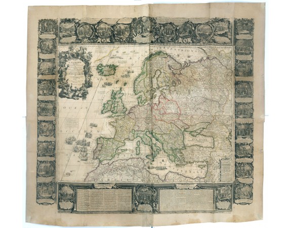
[NOLIN, Jean-Baptiste / Jean-Baptiste NOLIN II - L'Europe Dressée Sur les Nouvelles observations. . .
Date: Paris, 1700
Format: 463 x 599 mm.
Color: Beau col. ancien.
Condition: In very good. Some paper thinness on old folds. Backed with very thin Japan paper for protective reason. Paper size : 1395 x 1510mm.
Description
A rare and monumental wall map of Europe, with original outline colour, of four joined sheets, surrounded by text and vignettes printed on separate sheets.
Created in 1740 by Jean-Baptiste Nolin II, largely based on an earlier maps produced by his father. The map is surrounded by thirty vignettes of historical events from ancient times to 1700. In turn, each vignette is set within an elaborate baroque frame of a unique design, accompanied by textual narratives. The extensive text along the lower margin is entitled "Description Géographique de l'Europe."
Jean-Baptiste Nolin managed to marry decorative ornamentation with the most advanced rendering of geographical detail. The artistic élan of his compositions evinced a style that preserved the rhetorical ambitions of the Baroque ethic, while anticipating the playful elegance of the Rococo period. His masterpieces, many like the present wall map, were monumental in scale and represented Nolin's desire to overwhelm his competition in what was a very challenging market.
With the address "Paris: Chez J.B. Nolin le Fils Geografe sur le Quay de l'Horloge du Palais a l'Enseigne de la Place des Victoires entre le Rue de Harlay et le Pont Neuf, Avec Privilege du Roy A present Rue St.Jacques au Lion d'Argent.".
9 500€
- N° Reference: 36889
Etiquettes :
[NOLIN
, Jean-Baptiste / Jean-Baptiste NOLIN II - L'Europe Dressée Sur les Nouvelles observations. . .
, Europe
600€

![CORONELLI, V.M. - Flandra parte occidentale: dedicata all'illustrissimo et eccelententissimo S. Giorgio Cocco, senatore meritissimo. . . [together with] Zelanda e Parte Orientale della Flandra. . . . CORONELLI, V.M. - Flandra parte occidentale: dedicata all'illustrissimo et eccelententissimo S. Giorgio Cocco, senatore meritissimo. . . [together with] Zelanda e Parte Orientale della Flandra. . . .](https://www.loeb-larocque.com/eshop/image/cache/catalog/image/new_upload/31286-275x210h.jpg)
![DE HASSELN, Robert. - [Nouvelle topographie.... La France en ses neuf régions] Region de l'ouest. DE HASSELN, Robert. - [Nouvelle topographie.... La France en ses neuf régions] Region de l'ouest.](https://www.loeb-larocque.com/eshop/image/cache/catalog/image/new_upload/DE-HASSELN-Robert-[Nouvelle-topographie-La-France-en-ses-neuf-régions]-Region-de-l-ouest-275x210w.jpg)